Irrigation Ditches and Canals: Historic Water Management in Colorado

Irrigation Ditches and Canals: Historic Water Management in Colorado
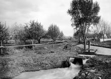
Irrigation Ditches and Canals: Historic Water Management in Colorado is an ArcGIS StoryMap detailing the statewide history of ditch irrigation in Colorado. Ditch-irrigation was - and still is - the backbone of Colorado agriculture. Unfortunately, due to their age and increasing demand for water, many historic ditches in Colorado have been, or soon will be, replaced with buried pipelines. Though often overlooked, these nonrenewable resources may yield unique information about past societies and environments, and provide answers for modern day social and conservation problems. This story map series discusses the history and practice of ditch irrigation on the whole, while using project-level data, photos, and documentation to tell that story from an archaeological perspective. The story is viewable in any web browser (on mobile, tablet, and computer - no subscription or software required) and blends text, photos, and other media with interactive maps that allow users to read about and explore individual NRCS irrigation projects and historic ditches in Colorado. Ultimately, this story map is a platform that will grow with future projects, eventually building a robust record of irrigation history that is easily accessible to the public and others.
Authors: Natural Resources Conservation Service
Keywords: NRCS, Irrigation, Ditches, Canals
Image Copyright: Denver Public Library